VertRep

VertRep

Friday, July 24, 2026

Getting Serious About Re-Arming the Force


It's a sign when a small company gets a big contract to move quickly in producing large numbers of additively manufactured missiles to catch up with the demand signal - a sign that it's time to move. See U.S. Navy Orders Low-cost Missiles to Expand Fleet, Allied Long-Range Maritime Strike Capabilities
CoAspire announced its selection for the Navy’s Coalition Heterogenous Affordable Offensive Strike (CHAOS) program this week. The Assistant Secretary of the Navy for Research, Development and Acquisition also confirmed the award in a Thursday social media post on LinkedIn. The American defense firm was awarded $70 million through Other Transaction Authority for the development of its Rapidly Adaptable Affordable Cruise Missile-Extended Range (RAACM-ER) for the sea service’s requirements. According to CoAspire, the RAACM-ER can be launched from land, air and sea platforms against maritime targets at ranges up to 1,000 nautical miles. This low-cost cruise missile has already been tapped by the Army and Air Force in recent months. The orders come amid a rush to replenish stockpiles exhausted in the U.S. war with Iran and in an effort to bolster long-range strike capabilities that are needed to counter China in a potential conflict.
You can read more about the RAACM-ER here:
RAACM has entered into full rate production at CoAspire's facility in Manassas, Virginia. CoAspire designed, built and flew RAACM off a tactical jet aircraft in four months, breaking all known records for air-launched weapon development. RAACM is additively manufactured, allowing for rapid prototyping and the development of variants quickly and affordably. RAACM variants, including the larger RAACM Extended Range (RAACM-ER) can provide long range, affordable mass strike weapon solutions for any US or international fighter or bomber or RPA that can deliver Precision Guided Munitions (PGMs). CoAspire is also developing surface-launched variants of RAACM-ER using a booster to launch it out of a canister that can be either ground or ship-launched.


Wednesday, July 08, 2026

Under Reported: US Navy Aid to Earthquake Damaged Venezuela

Back to 2 July 2026,


At the direction of U.S. Southern Command (SOUTHCOM) and the Department of War, assigned U.S. military forces are actively supporting Department of State-led disaster assistance to the people of Venezuela following the devastating earthquakes on June 24. The San Antonio-class amphibious transport dock USS Fort Lauderdale (LPD 28) and Freedom-variant littoral combat ship USS Billings (LCS 15) have arrived in the region to provide rapid, life-saving humanitarian assistance and disaster relief operations.

Marking the first visit by a U.S. Navy vessel to Venezuela in decades, Fort Lauderdale safely arrived pierside in La Guaira on the evening of June 28. The historic port call, executed at the direct request of the Venezuelan government, was preceded by U.S. Sailors and Marines delivering critically needed disaster relief supplies to the port via landing craft.


"Being directed at a moment's notice to transit into Venezuela presented a vast number of unknowns, but the one absolute certainty was the unmatched professionalism and work ethic of the Fort Lauderdale team," said Capt. Jiwan Mack, commanding officer of USS Fort Lauderdale. "We were able to safely arrive pierside and deliver immediate assistance to the Venezuelan people because of the incredible dedication of our crew.”

The presence of embarked Sailors and Marines is strictly humanitarian. As a highly capable and self-sustaining platform designed for extended expeditionary operations, Fort Lauderdale requires minimal local security, logistical support or port resources while pierside. This minimal footprint ensures that all local Venezuelan assets can remain entirely focused on domestic recovery efforts.

All photos from US Navy or Marines

Friday, January 02, 2026

Revisiting China's Sea Lines of Communication

In 2007, I posted on my blog a look at Sea Lines of Communication (SLOCs)(here).

Most of the links in that post are now dead or moved, but the subject is one vital to the US and other countries. One of those links contained the following from Stanley B. Weeks, a frequent SLOC commenter: "The increasing importance of SLOC security and access for states in the East Asia region will result in their increased attention to both military and non-military concerns regarding freedom of navigation. The United States, which shares the interests of the East Asian states in regional SLOC security and access, would undoubtedly welcome increased cooperation, understanding and support of regional states in upholding traditional principles of freedom of the seas so vital to seaborne trade." (1997) Also cited was a 1996 work, "Maritime Economic Interests & the Sea Lines of Communication Through the South China Sea" which can still be found at here.


Amidst other pertinent issues has this excellent map setting out "SLOC Blockages and Alternate Routes" - though it does not discuss the developing Arctic sea route above Russia, probably because it was not thought likely to be available at the time of writing.

I urge you to examine this map and contemplate what the Chinese leadership is trying to do to protect those SLOCs of vital interest to China.

Among other things, China is strongly urging its rights to the Spratly Island and to a large portion of the South China Sea. It is also seeking to protect a sea route around Australia by developing an Antarctic base or base from which shore based assets could protect shipping. Forther, China is trying to develop relationships with many of the island nations to the east of Papua New Guinea, such as the Solomons, Nauru, and others. This include an airfield on "Woleai, a remote atoll roughly 400 miles south of Guam". It should be clear why they are doing what they do - by any means - to get what they need.

China knows its greatest strategic weakness lies in its lack of internal resources and its need to control and preserve its SLOCs. In order to do so, it must find ways around the chokepoints of the first island chain that hems it in. 

Blue arrows point to major chokepoints

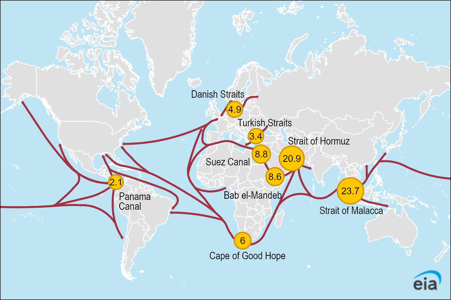
Figure 1. Daily transit volumes of petroleum and other liquids through world maritime oil chokepoints (million barrels per day) (2023)

Figure 1. Daily transit volumes of petroleum and other liquids through world maritime oil chokepoints (million barrels per day) (2023)

Data source: U.S. Energy Information Administration (EIA) analysis, based on Vortexa tanker tracking and Panama Canal Authority, using EIA conversion factors and calculations

Tuesday, December 02, 2025

More stuff coming soon


For a variety of reasons, I've let this blog be idle for a little while. However, I have some things that I'm working on and I'll be posting more soon.

Thank you for visiting and for your patience.